


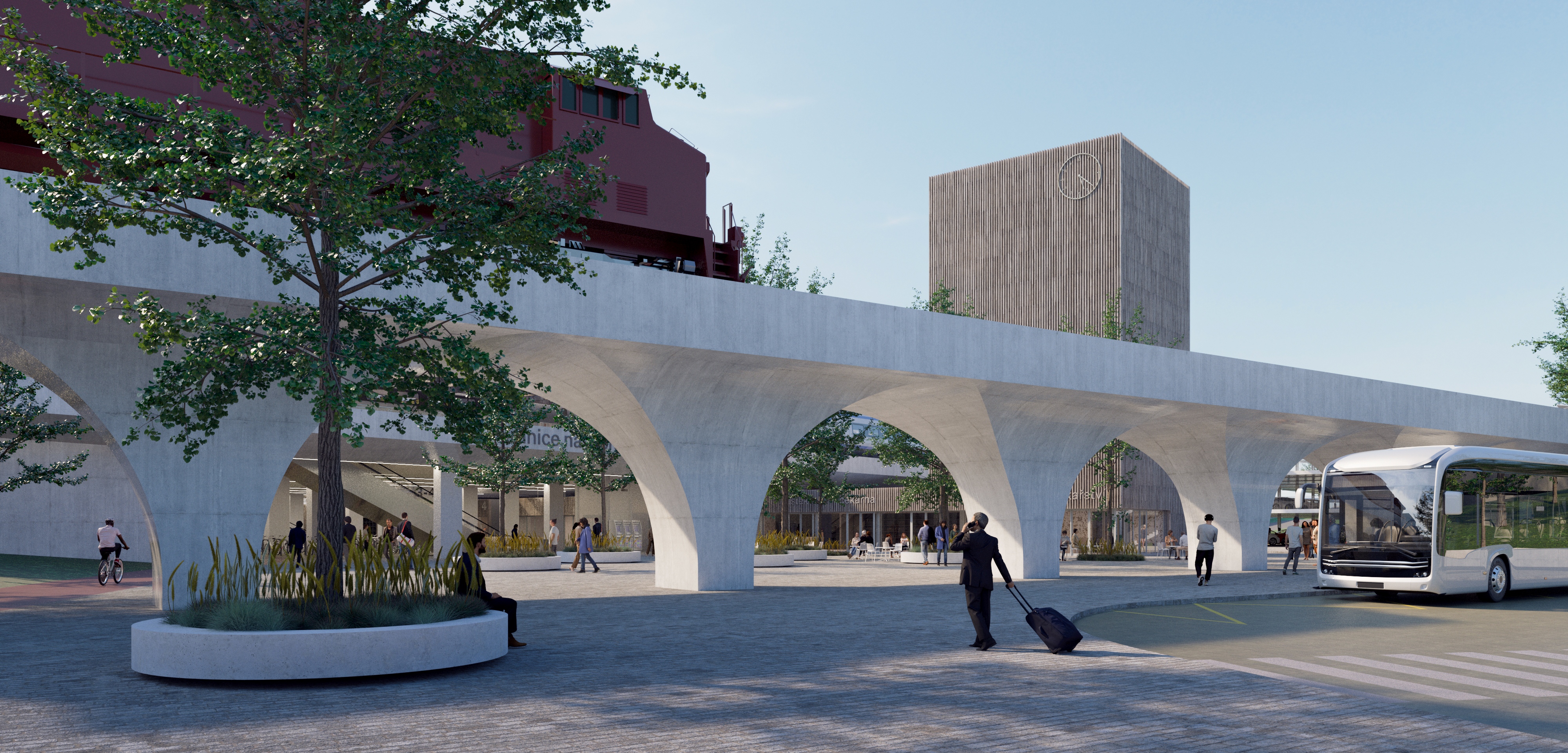
A crucial task for modern railway stations is to effectively counteract the barrier effect of tracks on the urban fabric. Although stations frequently play a key role in the spatial organization of cities, they rarely manage to dissolve the impenetrable urban boundaries created by heavy rail infrastructure. In the case of Hranice, however, it is precisely this railway development that will allow the city to expand into the greenfield areas to the north. Consequently, the new station building and its public spaces are tasked with creating a gateway between the developing city’s historic and new districts, seamlessly connecting them. In doing so, Hranice na Moravě station could set a precedent for the next era of railway construction, enabling sustainable rail transport to become a more seamless and integral part of our cities.
Perhaps the most significant and defining change in the history of Hranice na Moravě was brought about by the railway line constructed between 1844 and 1846, alongside the viaduct supporting it. The construction of the viaduct was necessitated by gradient limitations of the railway track and the need to ensure the unhindered flow of the Velička stream in its valley. The viaduct became an iconic landmark of the city, not only as a magnificent piece of engineering but also due to its height, which significantly shaped the city’s cityscape.
In line with 19th-century planning practices, the city’s railway station was built on the periphery to minimize disturbance to urban life and to allow room for spatial expansion. However, as in many similar cases, urban growth eventually reached the railway lines. These tracks primarily served the industrial areas that developed nearby rather than passenger transport, and made little connection to residential districts. As the significance of rail freight services shifted over time, the area surrounding the station turned into a brownfield zone, fundamentally defining its current urban character. The development brought about by the high-speed rail line and the new railway station will transform this situation, allowing the competition site to become a vibrant, popular area for local residents.
The essence of our urban planning concept can be summarized as follows: just as the viaduct allowed the free flow of the waters of the Moravská Brána towards the Bečva River, the proposed railway station should likewise provide a clear path for the city's future growth. This is achieved by maximizing connectivity across both sides of the railway tracks and bringing the new station into a central urban context through the proposed developments beyond the railway. Functionally, this means providing attractive housing for approximately 3000 to 4000 people in new residential areas, designed with optimal residential density, abundant green spaces, high-level services, and excellent transit conditions, fully leveraging the opportunities inherent in the 15- minute city concept.
Furthermore, we intend to mark the new focal point of Hranice na Moravě with a prominent new urban landmark, clearly visible both from afar and from passing trains. In designing the road network, urban structure, and implementation phasing of the new residential areas, we aimed to carefully account for existing conditions on both the northern and southern sides of the railway. At the center of the residential districts, adjacent to the tracks, we propose a new sports and recreation zone serving the northern district as a counterpart to the sports facilities located on the southern bank of the river.
To facilitate access to the new residential, sports, and service areas, we sought opportunities to strengthen sheltered pedestrian and bicycle connections to the existing city center, primarily along natural waterways. The exact pace and manner in which the proposed development for the entire area will unfold will be determined by an urban development strategy to be formulated through broad community engagement and in light of available financial resources.
Tamás Fialovszky, Gergely Kenéz, Detti Kolossváry
Intermodal hub
international open competition - 3. prize
Hranice, Czech Republic
Intermodal hub
international open competition - 3. prize
Hranice, Czech Republic
The historical viaduct spanning the Velička Valley defines the cityscape of Hranice as a landscape-shaping landmark. Evolving alongside the railway network, the viaduct was constructed in three phases: a brick-arched structure supported the track in 1844, followed by a second, stone viaduct in 1873 to accommodate track doubling. Construction of the third, two-track concrete bridge began in 1910. Arrayed side by side, these vaulted bridges of varying materials make a grand gesture within the landscape, a characteristic that serves as the key analogy for our redesign of Hranice na Moravě station. True to this parallel, the new terminal building is framed as an organic extension of the railway landscape. Rather than minor tunneling beneath the tracks, we propose a generous opening that houses most of the functional units specified in the brief. Alongside this bold spatial gesture, the abstraction of the viaduct appears in the structural support for the diverging freight line. A sequence of planned vaults acts as the primary motif of arrival.
Under our long-term master plan for the area north of the tracks, much of the surroundings will be transformed into a residential zone, establishing the station as a central urban organizer. The future city districts -currently physically divided by the rail line and topography- will converge here, driven by the goal of creating a clear, direct connection between both sides. Integrating the roadway and bicycle path beneath the tracks channels traffic from the northern territories, creating a balanced urban relationship. Furthermore, the underpass -expanded with terminal functions- offers potential as an alternative public space, engaging the local community from both directions.
Positioned at the core of the intermodal hub, the terminal building sits naturally between the parking garage, railway station, and bus terminal. The railway station remains close to the platforms, the bus terminal stays in its current location, and a high-capacity parking garage replaces the old terminal building, as suggested in the competition brief. This arrangement ensures all shared spaces remain easily accessible. Where the diverging freight track severs the link between rail and bus lines, an open, arched gateway -referencing the historic viaduct- reconnects the two stations. Enclosed by the tracks, a tree-lined public square serves as a waiting area for transferring passengers, animated by the terminal's active facade.
Rising within the enclosed urban square, the terminal building acts as a vertical landmark, marking the focal point of the rail and bus hubs and signaling the future town center. The tower provides spatial orientation while establishing visual links between levels: from the bus terminal, the path ahead is immediately clear, with the arched bridge appearing as the tower’s base. For arriving train passengers, the terminal's tall facade defines an intuitive direction from the platforms. Snake-like, the building weaves beneath the tracks, allowing future expansions to extend beyond the opposite side as a symbolic connecting element.
Reimagining the stereotypical dark and unwelcoming underpass, we propose an open, transparent spatial sequence. Housing station functions beneath the tracks activates the lower level and drives foot traffic. The tunnel is divided into two realms: the terminal building separates the busy roadway from the quieter pedestrian concourse. Commercial spaces feature inviting glass facades oriented toward the interior, while ticket machines, ATMs, and elevators stand cleanly alongside the structural columns. Glass-walled elevators preserve visual openness, and gaps left between the prefabricated bridge elements -fitted with a dense grid of skylights-bathe the underpass in natural light, creating a bright and welcoming public atmosphere.
In a transport hub, the rational arrangement of functions is paramount to ensure smooth, intuitive navigation. Conflict between transport modes is minimized by organizing bicycle, pedestrian, and vehicular routes in a logical hierarchy with as few grade crossings as possible. Circulation flows thread through the functional units, prioritizing efficient waiting and transfers. Passengers reach the terminal in various ways: some arrive by bicycle, purchase a ticket, and board a train or bus; others drive, park in the P+R garage, buy their ticket, and transfer to public transit. The seamless interchange between bus and rail remains the primary transfer dynamic on site.
To support an intuitive circulation system, the terminal’s main entrance is situated at the midpoint between the parking garage, railway station, and bus terminal. Core amenities, ticket sales, waiting areas, restrooms, and commercial services such as a bakery, cafe, and newsstand are shared across all transit modes, making their placement along key transfer paths essential.
In the long-term master plan, the station occupies a central urban position, embedding a covered public space while anchoring adjacent plazas and civic amenities. Extending the proposed underpass northwards creates a prominent public square for the future urban fabric, terminating in a envisioned civic building. A tree-lined plaza paired with a water feature offers an inviting gathering space for residents. Running parallel to the tracks on the northern side, a proposed recreation belt integrates sports facilities and green buffers designed to mitigate rail noise.
The organization of the space beneath the tracks -from active storefronts to bike parking- reinforces its identity as an extension of the public realm. Active facades of shops and restaurants act as subterranean streetfronts, catalyzing activity below grade. Cutouts and linear skylights between the tracks flood the underpass with natural light, elevating the space beyond a utilitarian transit tunnel. Paving materials from the outdoor plaza flow continuously under the tracks, creating a unified sequence of public spaces.
A sheltered urban plaza is formed between the platforms and the viaduct supporting the freight track, located right at the convergence of rail, bus, and parking facilities. Framed by a grid of trees, this paved square faces the main facade of the waiting hall, bakery, and cafe, extending outdoors into a shaded seating and waiting area. The spatial experience is heightened by direct visual connections to every element of the hub: trains on the platforms, cyclists entering the underpass, cars heading toward the garage, and buses arriving at the terminal. A green embankment along the western edge forms a soft boundary.
Positioned facing the city, the bus terminal requires a high level of aesthetic care. For visitors arriving from the main road, the design integrates paved vehicular surfaces within a wooded landscape setting. A tree-lined avenue flanks the primary pedestrian and bicycle access axis, while a park-like grove in front of the bus terminal creates a natural buffer and a relaxing waiting environment for passengers.